


Reprise Rando mai 22

Pascal Bernaud
User
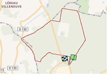

Length
9.3 km

Max alt
142 m

Uphill gradient
64 m
Km-Effort
10.1 km

Min alt
114 m

Downhill gradient
65 m
Boucle
Yes
Creation date :
2022-05-16 14:02:28.0
Updated on :
2022-05-16 15:50:13.32
1h47
Difficulty : Medium

FREE GPS app for hiking
 SityTrail
IGN / Geographical institutes
SityTrail Plus
The world is yours!
About
Trail Walking of 9.3 km to be discovered at Centre-Loire Valley, Loir-et-Cher, Montrichard Val de Cher. This trail is proposed by Pascal Bernaud.
Positioning
Country:
France
Region :
Centre-Loire Valley
Department/Province :
Loir-et-Cher
Municipality :
Montrichard Val de Cher
Location:
Unknown
Start:(Dec)
Start:(UTM)
362539 ; 5246622 (31T) N.
Comments